What Makes a Map Poster Look Good: A Design Guide for Zoom, Color, and Composition
Some map posters stop you in your tracks. Others look like someone screenshotted Google Maps and put it in a frame. The difference isn't the place — it's the design decisions behind the poster.
This guide breaks down what actually makes a map poster visually compelling, so you can go from "that's a map on a wall" to "where did you get that?"
The Single Most Important Decision: Zoom Level
Zoom level controls everything. It determines how much detail shows up, how recognizable the city is, and whether the poster reads as graphic art or a navigation tool.
Here's the key insight most people miss: the best zoom level depends on what makes your location interesting.
Wide Zoom (City Overview)
Pull back far enough and you see the full shape of a city — the coastline, the river bends, the highway ring roads, the way development thins out at the edges. This is where geography takes over and the map becomes almost abstract.
Works best for:
- Coastal cities where land meets water (Lisbon, Sydney, Cape Town, San Francisco)
- Cities defined by a river or harbour (London along the Thames, Budapest split by the Danube)
- Cities with a distinctive overall shape (Manhattan's narrow island, Venice's lagoon)
Common mistake: Zooming out so far that the city becomes a tiny cluster in the middle of a blank poster. If there's more empty space than detail, you've gone too wide.
Medium Zoom (District Level)
This is the sweet spot for most cities. You see the full street network, the relationship between major roads and side streets, the parks and waterways — but the map still feels dense and visually rich.
Works best for:
- Dense European cities with organic, winding streets (Rome, Barcelona, Prague)
- Grid cities where the street pattern itself is the visual feature (Manhattan, Chicago, Barcelona's Eixample)
- Any city where you want to capture the "feel" of the urban fabric without zooming in to read individual street names
This is the default for a reason. If you're not sure, start here and adjust.
Tight Zoom (Neighbourhood Level)
Zoom in close and individual streets become thick enough to read. The map becomes personal — this isn't a city overview, it's your neighbourhood. Your street. Your block.
Works best for:
- "Where we live" or "where we met" posters where the specific location matters
- Neighbourhoods with distinctive street patterns (the fan shape of Amsterdam's canal ring, the diagonal avenues of Washington D.C.)
- University campuses, small towns, or villages where a wider view would include too much empty surrounding area
Common mistake: Zooming in so close that the map loses context. If someone can't tell what city they're looking at, you've probably gone too tight — unless that ambiguity is intentional.
Why Some Locations Look Better Than Others
This is the uncomfortable truth about map art: not every location is equally photogenic. But understanding why helps you make any location look its best.
Water Makes Everything Better
Coastlines, rivers, lakes, and harbours create natural contrast on a map. They break up the street grid, add organic shapes, and give the eye somewhere to rest. A map of Chicago looks good partly because Lake Michigan creates a massive, clean edge along one side. Istanbul looks incredible because the Bosphorus cuts right through the middle.
If your location has water nearby, make sure it's visible in your crop. Shift the map so the river or coastline is a major element, not cut off at the edge.
Street Pattern Variety Creates Visual Interest
The most striking map posters tend to show a mix of street patterns. A grid on its own can feel monotonous. But a grid that breaks where it meets an old town centre, a river, or a highway — that contrast is what makes the poster visually interesting.
Cities like Paris are endlessly appealing as map art because the street pattern is complex: wide boulevards radiating from roundabouts, narrow medieval streets in the Marais, the rigid grid of newer arrondissements, and the Seine cutting through it all.
If your city is a pure grid (think Phoenix or most of the American Midwest), consider zooming in to where the grid has imperfections — near a river, a park, a historic district, or where two different grid orientations meet.
Parks and Green Spaces Add Breathing Room
Large parks create natural focal points on a map. Central Park in New York, Hyde Park in London, the Tiergarten in Berlin — these open spaces break up dense street networks and add visual rhythm. When positioning your map, consider whether a major park or garden can be included as a compositional element.
Composition: What Goes in the Centre Matters
The centre of your poster is where the eye goes first. Think about what you're putting there.
Strong centre choices:
- A river bend or harbour
- A major intersection or roundabout
- The place that matters to you (your home, a venue, a landmark)
- A park that creates a visual anchor
Weak centre choices:
- A featureless stretch of suburban grid
- The edge where developed land meets empty space
- A highway interchange (too much empty space around the ramps)
You can drag the map in the editor to reposition it. Spend a minute trying different centre points — the difference between a centred river and a centred highway interchange is the difference between art and clip art.
Choosing Colors That Actually Work
Color sets the mood of the entire poster. The map lines and shapes are the content; the colors are the personality.
Match Your Space, Not Your Favourite Color
The poster will live on a wall, in a room, surrounded by furniture and other objects. The best color choice is one that works in context. A few approaches:
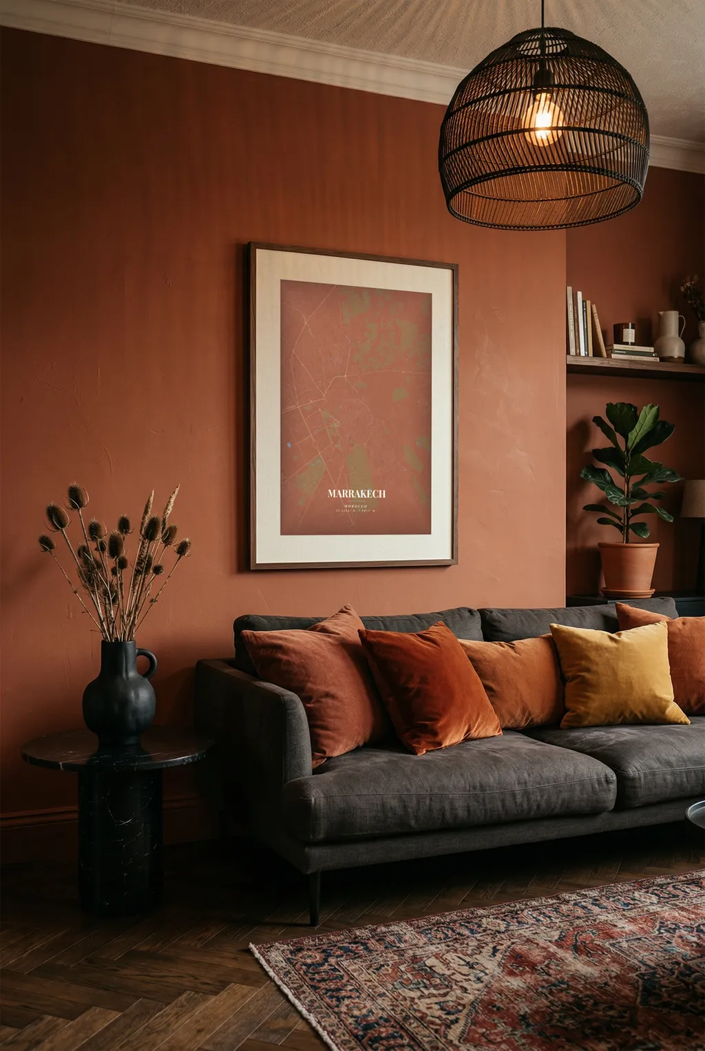
Pull from what's already there. Look at your room. What color is the sofa? The cushions? The rug? Pick a background color that complements (not matches) your dominant furniture color. A navy poster above a tan leather sofa. A warm cream poster against a white wall with wood furniture.
Contrast the wall. If your walls are white or light grey (most are), darker poster backgrounds — navy, charcoal, forest green, deep burgundy — will pop. If your walls are dark, a lighter poster creates the same effect in reverse.
When in doubt, go neutral. Black on white, white on black, or navy with cream. These combinations work in virtually every space and never look dated. You can always go bolder on your next poster.
Color Combinations That Consistently Work
Based on what actually looks good on walls (not just on screens):
- White background, dark grey or black lines — The Scandinavian classic. Clean, timeless, works everywhere. Lets the street pattern speak for itself.
- Deep navy background, gold or cream text and lines — Warm, sophisticated, slightly traditional. Excellent in bedrooms and studies.
- Black background, white lines — Bold and modern. Works especially well for cities with dramatic coastlines or river systems where the water creates strong negative space.
- Sage or olive background, cream lines — Soft, organic, current. Pairs well with natural wood frames and plant-heavy rooms.
- Warm grey background, white lines — Subtle and refined. A softer alternative to black-on-white that feels more sophisticated.
One Thing to Avoid
Don't pick colors that fight the map detail. If your background and line colors are too similar in value (lightness/darkness), the streets will disappear and you'll end up with a poster that looks washed out from more than a few feet away. Always make sure there's strong enough contrast between the map lines and the background to read the street pattern from across the room.
Text: Less Is Almost Always More
The text fields on a map poster are supporting actors, not leads. The map is the visual centrepiece — the text anchors it with context.
What Works
- City name + coordinates:
TOKYO/35.6762° N, 139.6503° E— Simple, geographic, works for any city. - City name + country:
AMSTERDAM/Netherlands— Clean and informative. - Place name + personal date:
Home/Since 2019— Emotional without being sentimental. - Just the city name, no subtitle: Sometimes one word is enough. Especially for well-known cities.
What Doesn't Work
- Long quotes or song lyrics that compete with the map for attention
- All-lowercase text on a poster that's otherwise crisp and structured (it creates a visual mismatch)
- Too-clever titles that need explanation ("The Coordinates of Us" only makes sense to you)
A good test: if the text would look odd printed on a museum placard, it's probably too much for a map poster.
Style Selection: Matching the Map to the Mood
Each map style interprets the same geographic data differently. The right style depends on the feeling you're going for and what the location looks like.
Minimal
Strips the map down to roads, water, and parks. No labels, no noise. This is the most versatile style and the safest choice if you're unsure. It turns any city into a clean graphic that reads as modern art from a distance and reveals its detail up close.
Best for: Modern interiors, gifts (universally appealing), grid cities where the street pattern is the feature.
Dark
The same clean data as Minimal, but inverted — light lines on a dark background. This dramatically changes the visual weight of the poster. Dark maps feel heavier, more dramatic, more intentional. They also hide wall mounting hardware better if you're going frameless.
Best for: Bedrooms, home offices, rooms with moody or industrial decor, coastal cities where dark water creates beautiful negative space.
Watercolor
Softer edges, muted tones, a more organic feel. The map looks less like data and more like illustration. This style works beautifully for locations with lots of natural features — parks, rivers, irregular coastlines — where the softer rendering adds to the organic character.
Best for: Living rooms, gift-giving (feels warm and personal), locations with lots of green space or water, anyone who finds the minimal style too stark.
Satellite
Real aerial imagery rather than rendered map data. This is a fundamentally different kind of poster — you're looking at the actual earth, not an abstraction of it. Satellite works when the landscape itself is spectacular: turquoise Caribbean water meeting white sand, the green patchwork of English countryside, volcanic islands, desert cities.
Best for: Coastal and island locations, rural or natural landscapes, anyone who wants their poster to feel photographic rather than graphic.
Putting It All Together: A Quick Checklist
Before you hit download, run through this:
- Zoom level: Does the amount of detail match what makes this place interesting? Not too much empty space, not too zoomed in to lose context.
- Centre point: Is the most visually interesting element (water, intersection, park, your specific place) near the centre?
- Water visibility: If there's water nearby, is it in the frame? If not, try shifting the map.
- Color contrast: Can you clearly see the street pattern from across a room, or do the lines blend into the background?
- Color context: Will this palette work on the wall where you plan to hang it?
- Text: Is it short, clear, and supporting the map rather than competing with it?
- Style fit: Does the map style match the mood of the room and the character of the location?
Spend two extra minutes on these decisions and the difference shows. A thoughtful map poster looks like a considered piece of art. A rushed one looks like a printout.